Documenting and understanding and the location of utility infrastructure is of critical importance– particularly when it comes to managing these assets at the world’s busiest airport.
Hartsfield-Jackson Atlanta International Airport (ATL) in Atlanta, Georgia, has been the world’s busiest passenger airport for the past 15 years, with more than 2,700 flights coming and going and serving more than 250,000 passengers daily.
Preparing for future trends in transportation, the airport has recently added new facilities and boasts a complex consisting of seven concourses and five runways, with the longest at close to 12,000 feet (approximately 3,600m). The entire infrastructure encompasses more than 4,700 acres (1,900 hectares).
Air transport is constantly expanding, and budgets continue to tighten. New strategies call for more efficiency, and this in turn calls for faster, more streamlined work processes and tools.
The best solution for substantially improving an airport’s efficiency is to properly manage and document the location and health of its infrastructure assets and utilities.
Operation and maintenance costs of running an airport have major impacts on budget planning and help enable a positive revenue balance at the end of the year.
ATL has an enormous amount of complexities to manage, document and monitor; and managing these present a significant challenge to accomplish effectively.
Like other airports of similar size, ATL consists of many different utility systems such as stormwater, sewer, aviation fuel, electricity, fuel pits, fat, oil and grease separation systems and telecommunications.
These in turn contain manholes, inlets and fuel hydrants. Any airfield pavement defects such as cracks, spalls or joint seal failures on runways and taxiways also need to be detected with repairs planned well in advance.
Each of these systems requires constant monitoring because of increasingly complex and demanding regulations. There are significant fines if proper compliance is not demonstrated.
GIS tools help airport staff to visualise all these utility systems on a single map, and help complete operational tasks faster and more effectively.
Asset management also documents the exact location of the airfield’s lights, signs and markings, and it is imperative that airport asset management knows exactly which light, sign or marking require service.
Modern GIS systems enable easy identification and simplify maintenance in a timely and cost-effective manner.
A new mode of data collection
For the past seven years, ATL has relied on survey-grade, GPS data-collection technology to collect utility, pavement and other critical infrastructure data with centimetre accuracy.
This equipment, however, uses proprietary software, and it is difficult to manage collected data throughout airport operations, mainly because it didn’t work efficiently with CAD, GIS planning or the workflows used by the airport’s engineering and GIS staff.
ATL had been looking for the right solution to map, collect and record their asset and utilities information in one centralised database and share this information between decision makers and field crews.
Three years ago, ATL made the decision to use Esri’s Collector for ArcGIS to collect and update data in the field using smartphones and tablets.
Airside and Landside Operation teams, who worked in the office on pavement management, required a common software interface to communicate with field crews efficiently and Collector for ArcGIS provided the missing link.
Collector for ArcGIS sets up the collection project, manages and edits the data all in real time, and exports it for use with other systems, such as CAD, with the ArcGIS Online environment.
Smartphones and tablets with Collector for ArcGIS installed were used by field crews and proved very popular.
Crews easily understood how to use the already familiar smart device interface and within a short period of time, were quickly collecting, viewing and sharing data in real time across multiple platforms – online and offline.
It was especially helpful for Airside and Landside Operation teams who could easily and simultaneously communicate with multiple field crews any edits made by each other.
Brian Haren, senior GIS program coordinator at Hartfield-Jackson, explains, “H-JAIA Landside and Airside Operations have a requirement to share information on airfield status and needed repairs in real time.
“In the past this meant identifying repair locations using imprecise methods such as verbal descriptions passed via email, text message or phone call.
“With Collector for ArcGIS, the crews can now share precise location, description and photo information in real time across the wide variety of platforms. This has resulted in more timely and efficient responses to critical airfield repair issues.”
 A new GIS
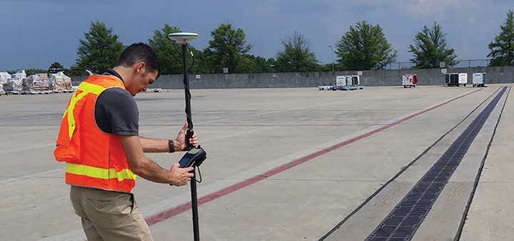
When word spread of the recently released Leica Zeno 20 handheld GIS asset collector running on an Android operating system, the airport was immediately interested.
This meant a survey-grade asset collection device could now achieve centimetre accuracy data collection that the commercial grade smart devices previously used could not provide. Because it used an Android OS, the device could also run Esri’s Collector for ArcGIS.
After testing Esri’s Collector for ArcGIS on the Zeno 20 using an external lightweight GNSS antenna on a pole, the Leica Zeno 20 provided the centimetre accuracy required by airport and field crews.
It also could map and record their data in one centralised databank and share this information in real time. The entire airport now worked with optimised workflows, with back office crews efficiently managing data and easily incorporating it into their GIS and CAD systems.
This combination of the Collector for ArcGIS app, Zeno 20 and ArcGIS Online Subscription has now been branded as the ZenoCollector.
With the ZenoCollector, field crews can view collected asset data with high-resolution background imagery on large displays.
Key decisions can quickly be made in real time, based on the quality and accuracy of the data collected using ArcGIS Online, a cloud-based mapping platform.
Project managers and other key personnel are also able to follow the progress of field data collection activities from their desktops or mobile devices as they occur.
Using the ZenoCollector enables ATL’s field crews to accurately capture numerous assets efficiently and communicate in real time with all involved, documenting the health of this complex infrastructure with survey-grade accuracy.
Over the course of time, decreased labour costs and proactive planning are possible, resulting in a vastly improved lifecycle of utilities and assets at the ATL.
“The Leica Zeno 20 running Collector for ArcGIS allows us to bring our high precision 2D data collection workflows completely into the ArcGIS environment. This means Esri’s ArcGIS Online becomes the hub around which all field data collection activities revolve, eliminating the need for separate third-party solutions and expensive desktop applications,” said Mr Haren.
“The ZenoCollector provides our Aviation GIS, Engineering and Facilities teams with an easy-to-use data collection experience that is consistent with our consumer-grade smartphone and tablet systems, yet provides the high accuracy and precision we demand for critical airport infrastructure location and identification.”
This partner content is brought to you by C.R.Kennedy. For more information, visit survey.crkennedy.com.au/products/gis.