Yarra Valley Water, Melbourne’s largest retail water utility, has made its asset data fully available online. The data is available 24/7 via an interactive online Asset Map, and through an open Geographic Information System (GIS), making it easier for other asset owners, planners, engineers and excavators to locate underground water and sewer systems.
Yarra Valley Water provides essential water and sanitation services to more than 1.8 million people, across Melbourne’s northern and eastern suburbs. Historically its asset data has only been accessible in hard copy format from either Dial Before You Dig, or from Yarra Valley Water themselves.
Previously the release of any data required digital license agreements to be signed, which meant the data had to be manually extracted by GIS staff. Yarra Valley Water also had reservations about the benefits of openly releasing asset data and about who it should be made available to.
Charles Moscato, Spatial Information Officer, Yarra Valley Water, said, “As the spatial industry moves towards augmented reality, utilities can benefit by releasing their data in open data formats. Not only is it better and easier for people who use the data, but with more utilisation of the data there’s ongoing feedback and the quality of data stored within the system improves.”
Damage control
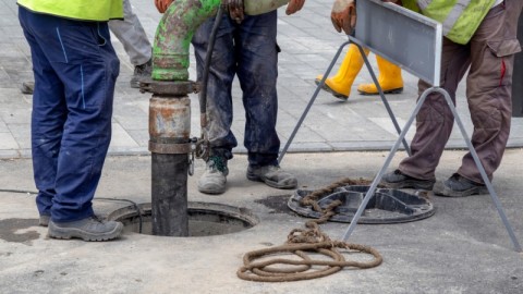
Being able to accurately identify the location of underground assets is an important safety consideration in order to protect workers, the public and the assets themselves. The rupture of an underground asset can cause serious damage to structures and potential injury, as well as the loss of essential services.
Damaged assets can be very costly to repair or replace, and Yarra Valley Water’s decision to offer online access to its asset data aims to greatly minimise the potential for harm.
“We have been providing the data via a CAD export, but the needs of our customers have changed, and today, anyone needing to plan around, build near or wanting to connect to Yarra Valley Water assets usually want access to digital asset information to understand asset features such as location, size, material and depth. More and more customers were requesting an extract of the digital data,” Mr Moscato said.
“Other utilities, developers and maintenance planners can now use our data within their own corporate systems. This makes it easier for us to work together and helps protect our assets from damage which is critical for continuity of service for our customers.”
Yarra Valley Water began digitising its asset data in the late 1980’s with the historical data translated from hard copy plans. In semi-rural areas such as Mitcham in the 1980’s, the data was digitised from 1:25,000 scaled asset plans, which meant that if the user was out by a millimetre when entering in the information, then the physical location of the asset equates to being 2.5m out.
Hence, the location accuracy of the asset information stored within the system can be 5-10m out in some locations, so it’s important for Yarra Valley Water customers to know the accuracy of the data due to the age of some of the asset information stored within the GIS.
Data integrity
Further improvements are in the pipeline with Yarra Valley Water progressively adding more detailed information about assets making the data more valuable. This includes adding a rating on the locational quality of the asset data using the Australian Standard 5488-2013, allowing users to make more informed decision about how they use it.
Precise knowledge of where and what a subsurface utility is and its status in its asset lifecycle can significantly reduce the possibility of interference with valuable subsurface utility infrastructure. The application of this standard is intended to provide much information on the locational accuracy and type of subsurface utilities than has been available in the past. For this reason, additional functionality is planned to assist people using the data to report back to Yarra Valley Water where data looks wrong, allowing them to investigate and fix any errors.
“Providing online tools to report data errors will be a significant business process improvement, giving customers the ability to help us to identify potential data issues. The more people using our data, the more information can be fed back into the system, which is good for everyone,” Mr Moscato said.
For more information on how to access Yarra Valley Water spatial data, visit www.yvw.com.au/help-advice/develop-build/access-asset-gis-information or go to www.data.vic.gov.au.